London’s architecture is a layered mix of heritage buildings, complex refurbishments and new development. In that environment, reliable site data is non‑negotiable. A laser scanning survey captures millions of points in minutes, producing a precise point cloud that we convert into measured building surveys, as‑built Revit models, and area measurement reports so architects, developers and owners can move forward with confidence.

 Accurate land surveying with Leica total station equipmentOur Surveying workflow

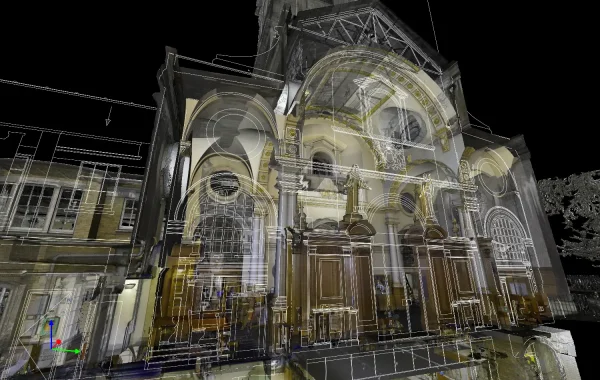
What is laser scanning?
A terrestrial laser scanner measures the built fabric with sub‑centimeter precision, generating a georeferenced point cloud. From this, our team produces:
-
- Measured Building Surveys – floor plans, elevations and sections suitable for planning and development.
- Scan to BIM (Revit) – intelligent as‑built Revit models for design coordination and clash detection.
- Area Measurement Reports – NIA/GIA schedules aligned with RICS guidance.
- Topographical Surveys – site levels, boundaries and features for design and drainage.
- Explore our services:

Why choose laser scanning surveys?
1) Accuracy in tight urban sites
Street canyons, irregular footprints and limited access make traditional tape‑and‑Disto workflows risky. Laser scanning captures geometry quickly, including soffits, cornices, vaults and irregular structures, ideal for infill, air‑rights and façade‑retention projects. 2) Fewer site revisits, faster decisions Comprehensive coverage means you rarely need a second visit. Designers can cut sections anywhere through the point cloud or use the Revit model for clash checks and setting‑out—accelerating design options, pricing and approvals.3) Planning and compliance support
High‑quality existing drawings and verified dimensions strengthen planning submissions, heritage statements and Rights to Light assessments. Where required, we provide NIA/GIA to support leasing and valuation.4) Ready for BIM and coordination
From scan to as‑built Revit, our models support coordination with structural and MEP disciplines, reducing abortive design and RFIs during refurbishment or CAT‑A/CAT‑B fit‑outs.What you receive from Modelling Architecture
-
- Registered point clouds (.rcs/.e57) referenced to OS grid/local control
-
- DWG 2D drawings – plans, sections, elevations at agreed scales
-
- Revit models (LOD per brief; typical LOD 300‑350 for architecture)
-
- Area schedules – NIA/GIA with annotated exclusions and floor plans
-
- Issue formats – DWG, RVT, IFC, PDF; shared via secure link
Survey quality & standards
We align outputs with recognised UK standards and client briefs:-
- RICS property measurement (2nd ed.) for area reporting (NIA/GIA)
-
- Historic England advice for heritage scanning and recording
-
- OS control and local site control as required for coordination
Typical London use cases
-
- Heritage refurbishments – create an accurate record before design; support listed‑building consent.
-
- Commercial fit‑outs – as‑built structural grids, slab edges and services for clash‑free CAT‑A/B delivery.
-
- Rooftop extensions – model parapets, plant enclosures and existing roofs.
-
- Rights to Light & Daylight/Sunlight – geometry for specialist analysis.
-
- Lease plans & acquisitions – fast, compliant plans and NIA/GIA for transactions.
Our Surveying workflow
- Brief & fee – agree scope, deliverables, LOD and timescales.
- Fieldwork – rapid, non‑intrusive scanning (out‑of‑hours available for retail/office).
- Processing – registration, QA checks and control verification.
- Production – 2D drawings and/or Revit model.
- Issue & review – secure delivery.
Accurate land surveying with Leica total station equipmentOur Surveying workflow
-
- Arena Central – comprehensive scanning for a Rights to Light study
-
- Measured Survey portfolio – examples of our measured surveys across the UK.
-
- Topographical examples – education and urban sites.