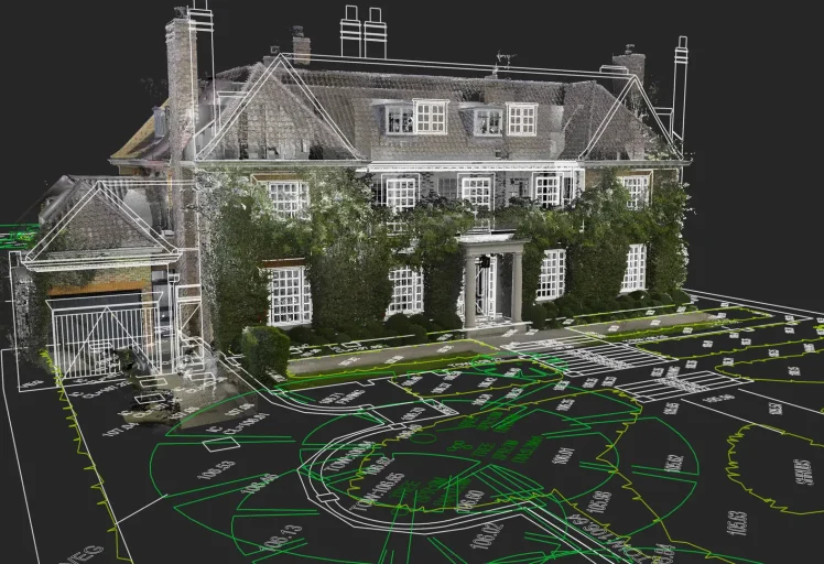
We use the latest Leica laser scanning technology, grounded in traditional survey principles that don't go out of fashion. Accurate to ±5mm, delivered across London and the south, typically within 5 working days
01
What is a Measured Building Survey?
A measured building survey captures the precise dimensions and features of an existing building, producing accurate technical drawings that reflect the structure exactly as it stands today, not as it was designed, not as it was supposed to be built, but as it actually is.
It’s the essential starting point for any refurbishment, extension, planning application, or building documentation project. Get it right at this stage and everything that follows is built on solid foundations. Get it wrong and you’re dealing with expensive surprises on site, usually at the worst possible moment.
At Modelling Architecture, we use Leica laser scanners and total stations to capture buildings to ±5mm accuracy, combining the latest survey technology with traditional measurement principles that have stood the test of time. Every survey is checked against our QA process before a single drawing leaves our office. We’re not in the habit of sending out work we’re not confident in.
We work with architects, developers, contractors, and heritage consultants across London and the UK, on everything from Victorian terraces to 200,000 sq ft commercial buildings. Same approach, same accuracy, whatever the size of the job.
What We Deliver
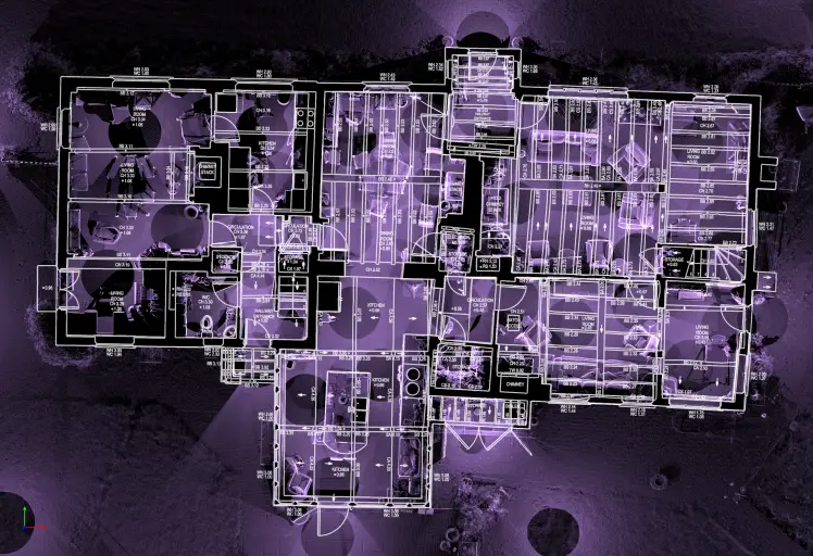
Floor Plans Fully dimensioned floor plans for every level of the building, produced in AutoCAD DWG to ±5mm tolerance. Every room, every opening, every level change. From a single-storey house to a multi-storey commercial building, nothing gets estimated or assumed.
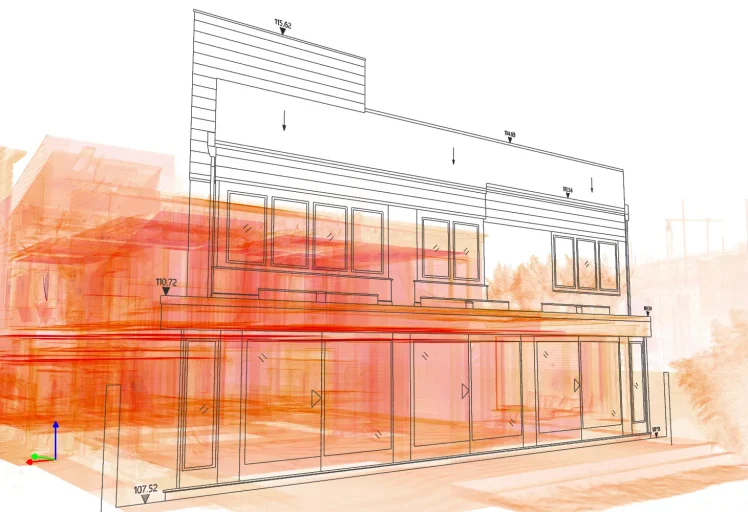
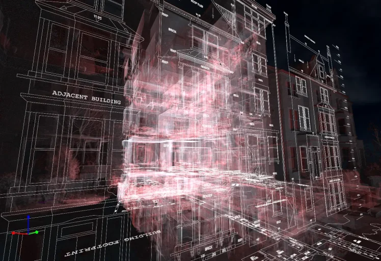
Elevations External and internal elevations showing the building as it actually exists, not as the original architect intended, or the contractor promised. Heights, openings, materials, and features recorded from what’s there.
Sections Building sections cut at agreed locations, giving a clear picture of internal heights, floor-to-ceiling relationships, and structural geometry. The kind of information that saves arguments later.
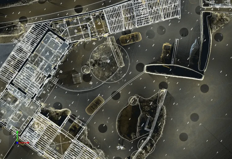
Topographical Survey Site levels, external features, and ground conditions surveyed using GNSS and total station equipment. Essential for any planning application, extension, or landscaping work, and considerably more reliable than scaling off an old OS map.
All drawings are delivered in DWG and PDF format. If you have a drawing template or CAD standard, we’ll work to it.
Need a 3D Revit model? That’s a separate service, see our Scan to BIM page for more detail.
Why Choose Us?
Why Choose Modelling Architecture?
We’re a London-based survey company that takes accuracy seriously. Not because it’s a nice thing to put on a website, but because a drawing with a 50mm error causes real problems on site, and those problems usually cost someone a lot more than the survey did. Every job we deliver is QA-checked before it leaves our office, and we’re always at the end of the phone if something needs clarifying.
We invest in the best equipment available, Leica laser scanners, total stations, and GNSS receivers, because the right kit genuinely changes what you can deliver. But equipment is only part of it. Our surveyors have the experience to know when something on site doesn’t add up, and the integrity to go back and check rather than hope it resolves itself in the drawings.
We work across all property types:
Period and listed residential properties
Commercial offices and mixed-use buildings
Retail units and shopping centres
Educational and institutional buildings
Healthcare facilities
Industrial and warehouse buildings
Heritage and conservation properties
From a two-bedroom terrace in Hammersmith to a 200,000 sq ft commercial building in the City, the approach is the same. Measure it properly, check it, deliver it on time.
Get a quote Tell us about your project and we’ll come back with a fixed price, usually the same day.
FAQ's
How much does a measured building survey cost in London?
Residential surveys start from around £1,000 for a straightforward house. From there, cost scales with size, complexity, and scope. A listed building with awkward geometry and restricted access costs more than a straightforward Victorian terrace, as it should. Large commercial projects are priced on application. We give fixed prices upfront, no hourly rates, no surprises on the invoice.
How long does a measured building survey take?
A typical house can be captured in a few hours on site. Larger or more complex projects requiring GNSS control, laser scanning, drone flights, and total station traverses can take a full day or more. We’ll always tell you what to expect before we arrive, and we won’t leave until we’re confident we have everything we need.
What is included in a measured building survey?
Our standard scope includes floor plans, elevations, sections, roof plans, and a topographical survey of the site. Internal elevations and MEP (mechanical, electrical, and plumbing) surveys can be added where required. We agree the full scope with you before the survey takes place, so the drawings we deliver are exactly what your project needs, nothing missing, nothing superfluous.
What accuracy do you work to?
Our surveys are delivered to ±5mm positional accuracy as standard, underpinned by a coordinated control network established using GNSS and total station traverses. Point cloud data from our Leica laser scanners is registered to that control network, meaning every element of the building is tied to a common datum. For projects requiring OS grid coordination or integration with wider site surveys, we work in OSGB36/OSTN15. We don’t just scan and hope for the best.
Do you cover the whole of London?
London is our home turf, but we work across the UK. Brighton, Oxford, Bath, and beyond. If your project is interesting enough, we’ll go further. Drop us a line and we’ll let you know.
Can you deliver in Revit format?
Absolutely. We’re firm believers that the construction industry deserves better than PDFs attached to emails with “see drawing rev C (superseded)” in the title. A properly built Revit model, coordinated to your project’s shared parameters and ready for your design team to work from, is what we do. See our Scan to BIM page for the full picture.